


Physical & Locational Characteristics
The WDM area covers an extensive area. In the west it borders for about 300km onto Botswana which implies that it serves as an important conduit between Botswana and the rest of South Africa. Not only does WDM share a border with Botswana, it also shares eco-tourism characteristics along the Limpopo River valley based not only on similar environmental traits, but also strong cultural and ethnic linkages. Within the province, Waterberg shares its borders with Capricorn and Sekhukhune District Municipalities. The southern boundary of the district abuts Northwest Province and Gauteng Province. The N1 (national road) and R101 are entry points from Gauteng Province, N11 is the entry point from Sekhukhune and from the Northwest the R159 and R133.
Waterberg is the largest of six districts and cross border councils making up the Limpopo province. The district is approximately 4 951 882 ha (36%) of the province's total land area of about 14 million hectares and responsible for almost 30% of the province's agricultural activity, including 15% of the provinces animal production. The Waterberg District Municipality is made up of six local municipalities and is classified as 90% rural: Bela-Bela Local Municipality; Lephalale Local Municipality; Modimolle Local Municipality; Mogalakwena Local Municipality; Mookgophong Local Municipality and Thabazimbi Local Municipality.
The area has two important links to the provinces in the south. It is strongly linked along the Lephalale-Thabazimbi- Rustenburg mining corridor. The N1 running north-south through the east of the WDM forges strong links with Gauteng as the economic hart of South African and the far northern parts of Limpopo and even neighbouring countries to the north. The N1 plays an import role in proving access in national context but its further impact on development or promoting development is not always clear. The fact that it by-passes the major towns and that it is functionally a national link might imply that its direct contribution to development in the region is limited. On the one hand it opens up the area for especially tourism activities but on the other hand it exposes the region to direct competition with Gauteng and Polokwane for commercial ventures and investment. WDM's links to the areas in the east are weak. This is mainly due to the lack of key economic activity nodes and topographical factors.
Table and Figure below present the relative land areas of the local municipalities within Waterberg district. Lephalale with close to 40 % contributes the greatest land area to the district, while Bela-Bela with approximately 6% of the total land area contributes least in terms of hectarage size.


Figure: Relative area size comparisons of the municipalities within Waterberg
Compared with the rest of the province Waterberg is unique as it encompasses little former homeland area, has an internationally acclaimed biosphere making up 15% of its total area. This creates its own set of challenges and opportunities. Waterberg consists mainly of commercial farms, game farming, etc. and only approximately 0.54% of the total area is used for settlement purposes (both towns and villages).
Map 1: Waterberg District Municipality

Source: Waterberg District Municipality, 2009

Source: Municipal Demarcation Board, 2007
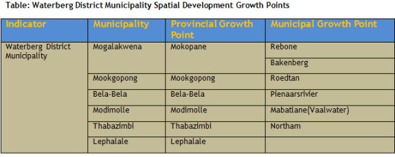
Waterberg district spatial development growth points
Settlement PatternsThe total area of the Waterberg District Municipality is approximately 4,951,882 ha. The municipal area consists mainly of commercial farms, game farming, rural settlements and small towns. Approximately 0, 43% of the total area is used for settlement purposes (i.e. towns and villages) of which 69% of all the settlements (i.e. towns and villages) in the Waterberg District Municipality area are located within Mogalakwena Local Municipality. The largest settlement consists of 5 000 people whilst the smallest has less than 1000 people. The low population densities have serious implications to improve the levels of service provision to the communities as cost associated with respect to the provision of service infrastructure is very high.
The spatial patterns differ from municipality to municipality whereby the urban areas (Mokopane, Mookgophong, Modimolle, Lephalale, Thabazimbi and Bela - Bela) dominate the district urban settlement pattern. Apart from these dominant urban centres, the district is characterized by a number of smaller towns that function as sub-regional service centres. The Spatial Development Framework of the Limpopo Province classifies the towns and villages in First, Second and Third Order Settlements to accommodate development and investment. It identifies Lephalale, Thabazimbi and Mokgalakwena as Provincial Growth Points. The District Spatial Development Framework divides the settlements into the following 1st order (one nodal point), 2nd order (5 nodal points) and 3rd order (4 nodal points).
The development of the space economy of the municipal area according to the nodes can be delayed since not all municipalities have adopted the Spatial Development Framework. To date, four municipalities namely: Bela-Bela, Mogalakwena, Lephalale and Thabazimbi have adopted SDF's, Mookgophong is awaiting adoption by council and Modimolle is in the process of developing the plan.
Settlements found are town, townships, villages, informal settlements and farms. There are 168 villages in Mogalakwena and 38 in Lephalale municipalities which make the district to be predominantly rural.
The land use patterns resemble a natural zonation with the mining sector/industry mainly concentrated on the periphery of the district whilst tourism and game farming activities take place at the central area. Commercial activities occur mainly within the transition areas and adjacent areas of the biosphere reserve.
The land is mainly used for conservation, crop farming, game farming, mining and small portion is used for settlement. The municipalities are still relying on town planning and township ordinance 15 of 1986 and old town planning schemes because the Land Use Management Bill is still to be enacted. Rural areas in municipalities that have traditional authorities in their jurisdiction have to involve the traditional authorities in the process as some of the land is in their trust. It is therefore very critical that relations are forged by the municipalities and traditional authorities.
The promulgation of the Land Use Management Schemes is not complete. Bela- Bela Municipality has promulgated its scheme whilst Thabazimbi, Lephalale, and Mogalakwena have started the promulgation phase. Mookgophong and Modimolle are in the process of developing the land use management schemes.
Land Reform and Land Tenure
Land is not equally distributed in Waterberg. Land reform issues within Waterberg District Municipal area are complex. There are challenges with regard to land access, land tenure, land restitution [Land claims] and land administration. Numerous land claims have been lodged with the Land Restitution Commission in the past. There are land claim backlogs in all municipalities. Approximately 252,342 hectares representing 40.80% of the total local municipal area of Mogalakwena is subjected to land claim. It is followed by Lephalale with 179,163 hectares representing approximately 9.14% of the municipal area, which is subject to land claim. The number of land claims in the other 4 municipalities is substantially less, with Mookgophong 40,243 hectares representing 9.42% of the total municipal area.
From a spatial point of view land ownership does not necessarily determine the preferred use of land. The exception are, as is the case with tribal land , where uses are restructured through restricted ownership practices, and where land restitution leads to commercially productive land becoming unproductive. The land restitution process can restrict investment and economic activity over the short and medium term but should not have an impact on the long term use of land.
The process and the capacity building of the beneficiaries to utilize the land are critical to uplift both the social and economic being of the claimants of the land. The key challenge for the district in the land reform process is to deal effectively with the injustices of land dispossession, equitable distribution of ownership, reduction of poverty and economic growth, tenure security as well as a system of land management which will support sustainable land use patterns. To deal with sustainably of agricultural land, the Waterberg District municipality has developed the agricultural land use policy to promote sustainable agricultural land use. In recent times the District has experienced an upsurge in terms of applications, illegal subdivisions and enquiries for conversion and change of farm land use from traditional agricultural uses to non-traditional farm uses such as game farming, golf courses, holiday accommodation, etc. The agricultural land is subdivided into unproductive or uneconomic land portions without proper assessment of the cost and benefits affecting the district's productive land for agricultural development and impacting negatively on the social, aesthetic and environmental quality of the local area.
The major towns and settlements are:
- Mokopane is the urban core of the area. It was established by the Voortrekker leader Hendrik Potgieter in 1852 and named Vredenburg as symbol of reconciliation between himself and the other Voortrekker leader, Andries Pretorius. Due to continuous skirmishes between the early settlers and the local tribes as well as the heavy toll malaria had on the people, the town was evacuated and only re-established in 1890. It was awarded municipal status 1939. The name was changed again in 2002 to Mokopane after the Ndebele chief who moved to the Waterberg area in the nineteenth century.
- Mookgopong was established in 1886 as a halfway house between Pretoria and Polokwane. It served as a trading post until 1907 when it was proclaimed as a town.
- Modimolle or Nylstroom as it was previously known, was established by a group of pioneers known as the Jerusalem Trekkers who believed they have reach the Nile and had been close to the Holy Land. The river flowed north and the koppie (Modimolle) looked like a pyramid. The town was established in 1866.
- Tshwana people settled in the 1860 around the warm water springs of Bela Bela. The town was established in 1882 and it got municipal status in 1932.
- Thabazimbi was established only in 1953 after iron ore discovered was discovered in 1919. The ore deposits were bought for Iscor and the town established for the employees.
- Lephalale is the youngest town in the WDM area. It was established in 1960 and got municipal status only in 1986.
Smaller settlements developed over the years. The more important ones are:
- Roedtan was proclaimed in 1956 as a small service centre for the immediate farming areas.
- Vaalwater was the end of the railway line from Modimolle and was established in 1925 to serve the grain farming communities in the area.
- Pienaarsrivier developed as a railway junction where the line to Marble Hall branched off from the main line. The railway line reached it in 1896.
- Northam was formally proclaimed in 1946. It later developed as part of the mining developments in the area.
The major land uses describes a development footprint closely aligned with physical and historical factors. The impact of conservation, crop farming, and subsistence farming on urban development is particularly noticeable. Rural development in its broader sense is compatible and consistent with most land use activities. Mining activities are affected mainly by existing urban development and environmental activities. In the same way crop farming is restricted by existing conservation areas, urban development and mining activities. Existing settlements and mining activities affects ranching activities, while in the case of conservation, subsistence farming is added to the equation.
The WDM consists of 161 proclaimed townships and 109 villages. The area has about 170 000 formal stands of which 8% are vacant. Rural settlements are all located in Mogalakwena and the northern parts of Lephalale. It is noticeable that the environmental quality in the more remote rural areas is significantly better than in the old black townships in the urban nodes. The villages in the rural areas are closely linked to subsistence farming. However, the types of farming differ in the sense that the villages closer to the mountains, are more cattle farming orientated while the villages on the plains are involved in crop farming. The extent of land that was not cultivated for a number years might be evidence of a declining involvement in farming activities. This might imply a shift from being self sufficient to being more dependent on other resources such as social grants or higher dependence on remittances from other urban areas. This might imply higher levels of migration and links to migrant labour.
The mining areas are fixed and clearly defined. It overlaps with a number of densely populated settlements. This area must be treated with special care in order to ensure that the rights of local residents are not affected while settlement and development should be managed in such a way that it does not unnecessarily impede on the mining activities.
Access and functional links
The dominant development potential is strengthened or weakened by its accessibility and links with the broader development environment. Access and functional linkages described by:
- Road and rail links.
- The mode of transport utilized by households.
- The accessibility of Mokopane as regional service centre.
- The functional service area of the urban core.
Road and rail links
The road network is the "heart" of the transport network in the Waterberg District Municipality, considering the long distances between production locations and markets. Transport and development go hand-in-hand, especially where public transport is concerned.
Roads are classed according to the function they have to perform. The main differences between the various classes of roads relate to the extent to which they cater for traffic movement or for access.
Freeways and toll roads are the responsibility of the National Roads Agency, while arterial, collector and local roads are the responsibility of the Limpopo Roads Agency. The municipalities are responsible for the road networks within their respective municipal boundaries.
Important Routes (And Roads) In Waterberg District Municipality
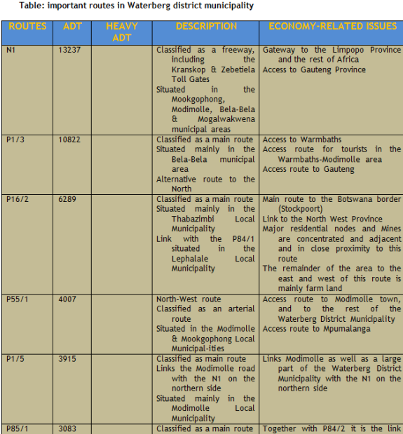
The traffic patterns in the Waterberg District municipality are as follows:
The major traffic movements are on routes between well-established towns and also on the routes linking up with other provinces and countries, namely:
- Towns; Bela-Bela, Modimolle town, Vaalwater, Lephalale, Thabazimbi, Mokopane and Naboomspruit
- Provinces; Gauteng, North-west and Mpumalanga
- Countries; Botswana
Most of the activities occur in the Bela-Bela Local Municipality, because this area is linked to Gauteng and therefore forms a corridor to the Limpopo Province. The area north of Mokopane has a great number of villages whose residents do their shopping in Mokopane. This fact explains the traffic patterns in the north of Mokopane (P31/1 and P19/1). The main route to Ellisras via Marken also lies on the northern side of Mokopane.
Although new roads have to be constructed to improve the road network, it is also important to maintain the current road infrastructure with the greatest care. It is for this reason that the Limpopo Roads Agency has opted for the installation and implementation of a highly sophisticated Road Management System.
The Waterberg District Municipality is in the process where the transfer of certain roads from the National Roads Agency will become the responsibility of the District and/or Local Municipalities. Currently a classification process to determine the status of all roads within the district is necessary and should be followed by a study on the condition of roads, which will become the responsibility of the Municipalities. The need for a District Strategy that will address the upgrading and maintenance of all roads (national, provincial, district and local) needs to be formalised.
The whole area is well covered by roads. The road network includes links to both the N1 in the south and the N11 running north-south through the area. The Lephalale-Rustenburg link via Thabazimbi forms an important north south link in the central western parts of the area. Lateral linkages do exist between the western and eastern parts of the WDM area. These links link the major towns but are constrained by the mountainous core of the area. All rail links runs north south with no lateral linkages.
The N1 links the municipal area to key axis through the province linking all centres north and south of WDM area. The fact that the N1 bypasses the main urban centres excludes the municipal area from fully benefiting from passing traffic although it remains the key national and regional links to the eastern part of the district area. The N11 passes only through Mokopane and provides an important link with the north western part of the province and Botswana. The general impact on the area is small. Locally it only serves the mines north of Mokopane. The route carries a substantial number of heavy vehicles which causes problems in Mokopane There are a proposal to reroute the N1 past Mokopane. The link between Modimolle, Vaalwater and Lephalale is substandard in terms of it function as a major link from the N1 to Lephalale. The extent of heavy vehicles that services the development in Lephalale causes problems and leads to deteriorating road conditions and dangerous driving conditions. The conditions on this road can largely be contributed to the bad condition of the link to Lephalale via Thabazimbi over Brits and Beestekraal. This link should be a logical route to serve the western parts of the area but it is substandard and cannot fulfil its function. It is not within the ambit of the WDM to resolve this issue but they should put pressure on the Provincial Road Agency to address this matter in cooperation with their counterparts in Gauteng.
WDM has a total road distance of 21 938km of which only 16% or 3 555km are surfaced. However, most of the roads in the proclaimed towns are surfaced but are not necessarily in a good condition. Unpaved roads in rural towns and most of the district roads are in a relatively good condition. One should note the fact that there are a number of road building and surfacing projects in progress. This will improve accessibility and mobility of people in general.

The provincial and regional context - accessibility
Although the municipal boundary describes the administrative unit, the function and impact of the urban core of the municipality does not necessarily follow the same boundaries.
The N1 links the municipal area to key axis through the province linking all centres North and South of the WDM area. The fact that the N1 bypasses the main urban centres, excludes the municipal area from fully benefiting from passing traffic although it remains the key national and regional links to the eastern part of the district area. The N11 passes only through Mokopane and provides an important link with the north western part of the province and Botswana. The general impact on the area is small. Locally it only serves the mines north of Mokopane. The route carries a substantial number of heavy vehicles which causes problems in Mokopane. There is a proposal to reroute the N1 past Mokopane. The link between Modimolle, Vaalwater and Lephalale is substandard in terms of its function as a major link from the N1 to Lephalale. The extent of heavy vehicles that services the development in Lephalale causes problems and leads to deteriorating road conditions and dangerous driving conditions. The conditions on this road can largely be attributed to the bad condition of the link to Lephalale via Thabazimbi over Brits (Madibeng) and Beestekraal. This link should be a logical route to serve the western parts of the area but it is substandard and cannot fulfil its function. It is not within the ambit of the WDM to resolve these issues but they should put pressure on the Provincial Road Agency to address this matter in cooperation with their counterparts in Gauteng.
The extent of accessibility is shown on the next map.

Map: Travel Time maps in Waterberg District Municipality
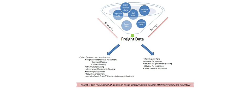
In freight logistics it is very important to understand and factor travel time between major nodes in the region and services places so as to arrive with optimum route choice and meet client delivery standards and maintain minimum service levels. An assessment based on one hour isochrones shows the following:
- All urban centres along the N1 are very accessible. This is in particular true for Mokopane, Mookgopong, Modimolle, and Bela Bela. These towns serve an area of high accessibility.
- Lephalale, Thabazimbi, and Marble Hall is relative isolated and there is a similar break between Bela Bela and Tshwane.
- The impact of geographical obstructions in separating the eastern and western parts of the WDM area is clear.
- The analysis shows the increased inaccessibility of the northern part of the municipal area. This also applies to the south western parts.
- Accessibility to major centres decreases rapidly as one get closer to the Botswana border.
- The central parts are relatively inaccessible due to the mountains and general lack of development in the biosphere area.
- Decreasing accessibility also correlates with a decrease in population and population densities.
The lines of least accessibility also describe each town's sphere of influence. This does not necessarily correlated with administrative boundaries.
Transport and mobility
Aspect regarding the roads and rail network was assessed earlier. The spatial pattern in terms of the modes of transport used by people mirrors the patterns described for most of the other variables assessed. Private transport is limited to the higher income areas of the urban core.
The larger proportion of people in the rural areas either travel by bicycle or by foot or not at all. This links to the stability of the area and the period of residence of most of the households. Overall taxi and bus services are not significant in terms of numbers but they are both very important in terms of their services and impact on development. There seems to be a larger dependency on taxi's and buses in the western towns than in the towns along the N1. Animal traction plays a very important role in rural areas. It bridges the gap between moving on foot and using motorised transport. The impact on traffic is important and it contributes to a mixed mode of traffic along major routes. Rural freight and small volume logistics is an area requiring development with existing locally based initiatives requiring up-scaling.
Social services
Access to social facilities plays an important role in local development. The spatial system in WDM is well established and has developed over many years. However, issues with social facilities highlighted in the local IDP emphasise needs around education and health. It is not possible to determine the nature of the needs for schools, clinic, etc. In this assessment the emphasis is on the quantitative aspects or specifically the access of communities to these services. The next map shows the general distribution of these facilities throughout the municipal area.
Nodes as development focal points
The Limpopo Provincial Spatial Development Framework recognised and proposed an extensive hierarchy of settlements (5 levels). In terms of the growth and development prospects in the municipal area it was necessary to reduce the number of nodal points and adopts an approach where development efforts can be focused on a smaller number of nodal points but in this case nodal points with a very specific role and function in the development of the municipal area. For this purpose the nodes in the Waterberg District Municipality are divided into 1st order (one nodal point), 2nd order (5 nodal points) and 3rd order nodes (4 nodal points).
First order node - Mokopane/Mahwelereng Mokopane/Mahwelereng is the only proposed 1st order node. This is because of its growth potential and its strong orientation as the largest regional service centre in the Waterberg District Municipality's area of jurisdiction. The assessment of the economic base of the different municipal areas in the district municipality has shown that Mokopane has a well-diversified economy in the provincial context with it strengths lying in the secondary and tertiary sectors. Development in this node is also linked to good mining prospects in the future which will again strengthen diversity and the ability to develop its roles as a key service centre.

Map: Priority development nodes in the SDF
Second order nodesThe second order nodes in the municipal area are represented by the five other well established towns in the municipal area. However, each of these nodes has unique characteristics that define different roles for each in the development of the municipal area. The common denominator between all of them is that each fulfills a service centre role to a lesser or greater extent.
- Bela Bela
Bela Bela is the strongest agricultural area in the Waterberg but it also shows comparative advantages as a strong service sector in both the national and provincial economies although community and social services is not a basic activity. It is the focus of large scale tourism activities and for the hub of tourism outside the proclaimed nature reserves and Waterberg Biosphere.
- Modimolle
This node is the focus of strong agricultural activities and has a clear services centre role in the Waterberg. The service centre role is however weaker when compared to the national economy. It is expected that Modimolle will also develop more as a tourism support centre and a gateway to the heart of the Waterberg Biosphere.
- Mookgophong
This node is primarily a services centre supporting strong agriculture hinterland and existing mining activities in close proximity to the town.
- Thabazimbi
Thabazimbi is the only second order node which is dominated by single sector. It is predominantly a mining town with a very week services sector. However, it still plays the role of a local service centre but not to the extent of the other first and second order nodes. Mining activities is currently focused on iron ore but indications are that this activity has a very short life span (2014) left. However, indications are that the long term mining activities will shift to platinum. This is a crucial shift in the sense that the ability to establish platinum mining activities to the same extent as the current iron ore activities is central to the long term survival of the town. Thabazimbi clearly illustrates the vulnerability of an undiversified local economy. Economic diversification should a central theme in local economic development. The obvious sectors to develop are agriculture and eco-tourism. Thabazimbi needs to develop as the eco-tourism gateway to the area between the Waterberg Biosphere and the Limpopo River. This option is however constraint by the status and condition of the R510 (Rustenburg area) and R511 (Gauteng) feeding it from the south.
- Lephalale
Lephalale's remote and relative isolated location is countered by the prospects of a growing mining and electricity sector in the immediate vicinity of the town. Its role as service centre is week and will remain to fulfil a much localized role in the light of its low density hinterland with low population numbers.
Third order nodesThe 3rd order nodes are: Northam, Vaalwater, Bakenberg, and Rebone. These nodes play important roles as regional services centres. These nodes fulfil a lower order service function although there are district differences between them in terms of its long term development potential and roles in the development of the municipal area.
- Northam
Northam is a node sustained around the local mining activities in the area. The mines are delivering services to private towns. These activities has nevertheless attracted large numbers of informal settlers which poses direct challenges to the local municipalities financial sustainability and its ability to extend service delivery (or not) to this area. The future role of Northam will increase in importance as mining activities in the area shifts from iron ore to platinum. Developing Northam as part of Thabazimbi's economic diversification process can be important for the region in the long term.
- Vaalwater
Vaalwater was initially developed as service centre for local farms. It is however in the beneficial position to develop as the hub of the Waterberg Biosphere. This role will most probably focus on a stronger service centre function. The development of Vaalwater will however, be a response to the ability to enhance role and function of the Waterberg Biosphere as a prime eco-tourism destination. Job creation and local economic development should be focused on the farms, resorts and protected areas in the biosphere. Vaalwater is clearly not a centre for welfare directed support but should be protected from investments without a clear economic rationale. The low cost housing that was provided in the node is an example of inappropriate development that should rather be directed to the second order nodes where there is better change of sustaining pro-poor development strategies.
- Brakenberg, Rebone and Beauty/Gaseleka
These settlements are in terms of their profiles and the SDF proposals very low order municipal service points. The emphasis here should be on creating opportunities for establishing regional community facilities and services if required. It implies that the current ad hoc disperse nature government services in the adjacent rural areas should be avoided in future. The limited scope for development and the inability of the local municipality to apply cost recovery in these areas should determine the level and types of development promoted in these nodes.
Movement and movement systems play a very important role in the growth and development of areas. The development of a sustainable nodal system is dependent on the free and unrestraint movement of goods and services. Movement is central to nodal development and the extent and ability to generate movement of people goods and services lead to the ability for geographic centres or nodes to specialise and develop. Improved movement and hence improved accessibility of nodes and thus the ability to develop. It is therefore critical to determine the most important roads in the municipality and develop strategies to optimise movement between and access to the nodal points in the municipal area.

Map: Networks and corridors in the SDF

The most important roads in the WDM include:
- The N1Highway which provides inter regional linkages.
- The N11 which follows a north-south direction through Mookgophong, Mogalakwena and a small part of Lephalale and is the link between the central areas of Limpopo and Gauteng to the north western parts of Waterberg and Botswana. It is playing and increasingly important role in opening up the mining areas north of Mokopane.
- The R33 from Modimolle to Vaalwater to Lephalale which provides the primary link with the Waterberg Biosphere..
- The R510 which links Lephalale, Thabazimbi and Northam with the platinum core of Rustenburg in the south.
- The R518 from Mokopane, to Lephalale that links the two nodes.
- The R511 that links Thabazimbi via Beestekraal and Brits with Gauteng.
- The R101 that runs parallel with the N1 and provides an alternative link between Bela Bela, Modimolle, Mookgophong and Mokopane though to Polokwane.
These roads form the basis for developing and linking the major nodes in the area. However, these roads are not the responsibility of the District Municipality but are central to sustaining development in any part of Waterberg.
To enhance the function of these networks they need to be treated as development corridors. A development corridor can be defined as "� a linear strip of land or area, connecting large activity nodes, traversing urban or inter-urban areas, surrounding a major transport facility or facilities providing an appropriate regional level of mobility and accessibility to adjacent areas, and containing a high concentration of population and mixed land uses" and "� accommodate major linear transport routes like heavy and light rail and/or freeways, large shopping concentrations etc., social, cultural and sporting facilities as well as a large amount of residential accommodation". The typical elements of a development corridor are -
- Major movement infrastructure such as a railway line or highway acting as the spine of the corridor;
- Supporting movement infrastructure such as local access to roads that will provide access for land uses situated adjacent to the main movement spine (typically the main movement line provides a high level of visibility to land uses while adjacent roads provide access to land uses.)
- The main movement spine should preferably act as a conduit of public transport, with public transport facilities located along the corridor.
- Forces of attraction along the corridor, such as major destination points along the corridor creates the development impetus for eventual linear development along the corridor
- High intensity land uses along the length of the corridor.
The proposed corridors for the Waterberg District Municipality are:
a.The N1 Corridor, which is the most important road in the Municipality, with a high concentration of activities along this route. b.The R 510 Corridor, which starts from Northam and continues north through Thabazimbi to Lephalale. This corridor along with the N1 corridor forms the two most important linkages in the Waterberg area. c.The R516 Corridor. This corridor is an important linkage between Bela Bela and Lephalale. d.The R33 corridor. This corridor starts at the intersection with the N1, south-east of Modimolle and continues through to Vaalwater and ends at Lephalale. This corridor is important in terms of tourism activities and improved access to Lephalale. e.The R518 Corridor. This corridor moves from Mokopane in a north-westerly direction to Marken and ends at Lephalale. Viewed spatially, the above mentioned five corridors form a grid-like network through the Waterberg area, linking all the major activity areas and nodes to one another, and provides for efficient and equal access to all parts of the district. These roads should therefore be improved and maintained as the top priority.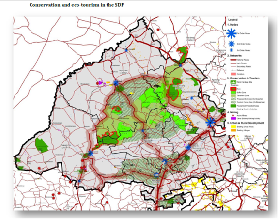
Map: Conservation and eco-tourism in the SDF
The protection and management of the Waterberg's natural environment is important for the following reasons -
- The ecological integrity of the natural open space is important in order to maintain natural systems and processes.
- The protection of the natural visual quality of the area which increases the attractiveness, liveability, and investment potential of the area.
- The natural open space plays an important role in the social, mental, and physical well-being of residents and tourists.
- The natural environment forms the basis of tourism in the Waterberg area and it is therefore imperative that the natural environment is conserved to ensure the long term sustainability of the tourism industry.
The following generic principles apply to the natural open space system:
- Conservation areas are mixed used areas and should be able to accommodate a range of uses depending on the status and function of a particular conservation area.
- The natural open space system should be protected from intrusive and ad hoc developments that damage the ecological integrity as well as visual quality of these areas. These might include urban development, mining activities, and agriculture in forms incompatible with conservation and tourism.
- Focus should be placed on resources allocated to those consolidated natural open space areas where long term ecological sustainability can be achieved.
- Although the Spatial Development Framework's aims to make development proposals that respects the ecological integrity and environmental sustainability of the area, It has been necessary in certain instances to re-evaluate environmental potential against development potential in order to achieve truly sustainable development for the area.
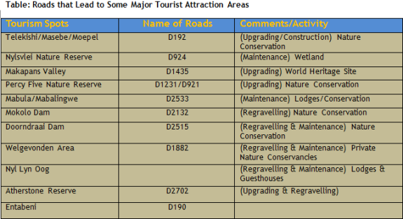
Important conservation and eco-tourism areas
This report makes a distinction between four areas concerning conservation and eco-tourism. The fact that some areas are not included does not mean that the conservation and environmentally sustainable practices are not priorities for the Council.
The Makapan's World Heritage siteMakapan's Caves has a longstanding relationship with historians and archaeologists but is relatively undeveloped and inaccessible to the general public. Visits to the Makapan's Valley must be arranged in advance by contacting the Mogalakwena Bushveld Community Tourism Association. The site is however developing as the backbone in linking conservations initiatives across the province.
The Waterberg Biosphere and proclaimed nature reservesThe Waterberg Biosphere plays a pivotal role in conservation and eco-tourism in the Waterberg District Municipality. It is important that the environmental heritage, conservation areas, biodiversity hotspots and ecologically sensitive areas be actively protected, managed, and enhanced to ensure that they are not adversely affected by other activities. The biosphere is also something that all the local municipalities in the district share and it is therefore the responsibility of the Waterberg District Municipality to help and develop the biosphere.
The biosphere does allow for activities such as farming, and eco-tourism. To ensure that the ecological integrity of the Biosphere stays intact uses such as mining, large scale intensive agriculture and human settlement activities should be avoided. The Biosphere comprises of three zones namely:
- The core.
- The buffer zone.
- Transition zone.
These zones seem to be ineffective, as there is no logical movement from the core, to the buffer, to the transition zones. These zones of the biosphere will have to be reviewed to create a better manageable area. Activities in the core zones should be restricted to activities which does not compromise the environmental integrity of the area, while the buffer and transition zones may allow for more intensive activities.
The SDF also proposes that the Biosphere be extended to the north and the south of its current boundaries. Because of the low agricultural potential and the geography features it make sense to include these additional areas as indicated on the framework plan. This would further allow for more tourist-type developments and support conservation and biodiversity in the area. The Waterberg biosphere is currently underutilised and should be developed in the flagship development project of the District Municipality.
Tourism focus area (ex-biosphere)
High levels of tourism activities are prevalent in southern parts of the municipal area. The first is in the Rust Der Winter area to the east of Pienaars River. This are provided opportunities linking tourism and conservation activities in Gauteng. The second and more important area is a band that runs east west from the Nylsvlei Nature Reserve to Leeupoort in the west. Bela Bela and Modimolle are in the core of this area. This area differs from the biosphere in the sense that it has strong commercially linked tourism facilities and caters for a different market than the biosphere. As indicated in the analysis, this area compromises of high intensity, and a large variety of tourist activities, and attractions. It is an area with large biodiversity and offers a range of morphological types that can be utilised to further develop it. This area is ideal for investment in tourism as this activity is playing an increasingly important role in the affected municipalities.
Mining
The increasingly important role of mining in the local economy is recognised by the Council. However, mining is driven by international commodity prices and economic conditions. The Council will therefore support the mining sector in terms of land and services availability but in such a way that it does not take on responsibilities in terms of business risks of the mines. Demands on the municipalities from the mining sector must be met by performance guarantees from the mines to mitigate investment risks for the Council. Development in the mining area indicated in the SDF will be done in close cooperation with all stakeholders. In this regard the communities are recognised as very important and the Council has the obligation to protect their rights as in the same way that they recognise the rights of the mining companies. All development in this area will still have to meet all required environmental and developmental criteria. The location of mining activities in an area is linked to the availability and location of natural resources. Mining activities are present across the Waterberg but there are clear areas of intense mining around Mokopane, Lephalale, and Northam-Thabazimbi. Where such resources are located adjacent to urban environments the mining activities pose a constraint to development and hence play a decisive role in the direction of urban growth. Mining in the WDM is a prominent spatial feature in the form of:
- The Ellisras coal fields.
- The Potgietersrus (Mokopane) platinum belt.
- The Potgietersrus (Mokopane) tin field.
- The Springbok flats coal fields.
- The Elands tin fields.
- The Rooiberg tin field.
- The Northam-Thabazimbi iron and platinum mining complex.
It is important to remember that when mining activities close the physical legacy of the mining activity remains in the form of a broad band of land which:
- Has potentially been sterilised for development through the properties of the mine dumps, silt dams and the undermining of the land;
- Presents a physical barriers, preventing spatial integration between these areas, and
- Has left visual scars on the urban landscape.

Map: Mining within the SDF
While mining is recognised as pillar of the local economic base and key job provider, the long term impact thereof should be carefully considered. Current indications are that with the exception of one or two protected areas there is no direct conflict between mining and prospective mining activities and the major tourism and conservation areas in the municipality. Of concern is the visual and physical scars left on the environment by mines that have closed down. The rehabilitation of existing mines should receive specific attention and should be done in accordance with the Councils broader development strategy.
The mining industry in the municipal area contributes to the economic development of the District and Province. Waterberg area is the largest production area of platinum in the Province. Mining of coal and petroleum development in Lephalale has increased demand for the commodity for electricity generation. The coal resource in the Waterberg field is estimated at 76 billion tons, which is more than 40% of the national coal reserve. There is also mining of cement and iron in the municipal area. The Waterberg area host 70% platinum reserves in Limpopo Province followed by the Sekhukhune District. The platinum mining activity is found in Mokgalakwena and Thabazimbi.
Amandabult and Union section in Thabazimbi have 130 million tons of proven ore reserves between them and the current mining rate is approximately 6 million tons per year between them. Potgieterus Platinum has proven reserves of 280 million tons and its current extraction rate is 57 million tons per year. The municipal area still has the potential of expanding mining activities; currently PPRust Mine is to further expand production to an additional 230,000 ounce of platinum.
The Kumba Iron Ore in Thabazimbi is reaching its lifespan while the existence of the town is dominated by mining activities and government services. It is anticipated that the mine will close by 2013. The coal, energy and petrochemical cluster within which the Waterberg District municipality falls in the Limpopo Provincial Development Strategy is important for the development of the Nation, Province and region. The development of the cluster in Lephalale is in the second phase of constructing Medupi Power Station which is expected to deliver electricity to the country by 2013.This requires doubling of Grootegeluk (Exxaro) mine and its beneficiation plant by 2012. A petrochemical production facility in Lephalale is under consideration to utilize the chemical grade material.
The construction of Medupi Power station, the expansion of Grootegeluk and petrochemical production facility will require expansion of accommodation both the mix of single and family units in Lephalale and adjacent municipalities. The development has an impact also on municipal services; including infrastructure and social services. The conditions of roads where mining activities are taking place is worrisome, especially the R33 between Lephalale and Modimolle are currently the busiest road in the District area. It has reached a level of collapsing as there is a high volume of traffic between the two towns. Maintenance and rehabilitation plans and schedule has to prioritize and be sensitive to such realities. Exploring a formula for private public partnership with mining companies to adopt or contribute to the road maintenance of such roads may be critical.
ROADS
Roads that are currently on the five-year plan of Roads Agency Limpopo are indicated in the table below. The busiest road on the plan, with an annual average daily traffic count of 1,723 vehicles, is the road from Gakgabudi through Mapela to Marken. This road is central to the improvement of logistics for expanded platinum mining on the Platreef. Due to budget constraints it will take five years from 2005/06 to 2009/10 to complete 75% of this road that is 86 km long in total at a cost of R132 million. Another R40 million is on budget for the remaining stretch of this road after 2010. (The section from Gakgabudi to Mahwelereng is considered to be in a good condition and is not scheduled for upgrading)
The second busiest road is from Koedoeskop to Northam and Dwaalboom. This road is also crucial in terms of mining logistics, specifically for the new cement kiln that is currently under construction at Dwaalboom. Construction costs are partially provided for in 2007/08, but with no provision for the rest over the planning period. Road D1639 is not very busy, but is central to platinum mine expansion at Northam. Construction costs were partially provided for in 2005/06, but once again with no provision for the rest over the planning period. Roads that are already on the tarring programme after 2010 and that are important for the mining sector include:
- Completion of the Mapela-Marken road, and
- Linking Polokwane with Lephalale via Gilead and Marken.
The most crucial road for mining development in WDM, but that is not on the RAL strategic plan due to the substantial costs involved, is the R33 from Modimolle to Lephalale.
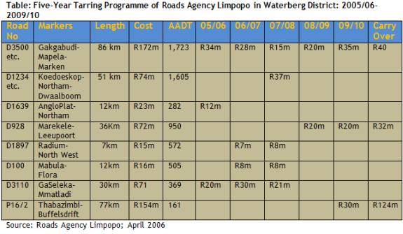
The principal strategic issues are, firstly, the slow progress in upgrading priority mining roads due to budget constraints at the Roads Agency Limpopo (RAL). Secondly, a discontinuity exists between RAL and the South African National Roads Agency (SANRAL) with regard to the transfer of priority roads such as the R33 between Lephalale and Modimolle, from the provincial to the national road networks. RAL believes that this road is too expensive for it to construct and maintain. However, SANRAL is not convinced that this road fits the strategic profile to be incorporated into the national network, and has therefore made no budgetary provision for its reconstruction as yet.
With regard to upgrading, the busiest mining road in Mogalakwena Local Municipality, with an annual average daily traffic count of 1,723 vehicles, is the road from Gakgabudi through Mapela to Marken. This road is central to the improvement of logistics for expanded platinum mining on the Platreef. Due to budget constraints it will take five years from 2005/06 to 2009/10 to complete 75% of this road that is 86 km long in total at a cost of R132 million. Another R40 million is on budget for the remaining stretch of this road after 2010.
The busiest mining road in Thabazimbi Municipality is from Koedoeskop to Northam and Dwaalboom. This road is crucial in terms of mining logistics, specifically for the new cement kiln that is currently under construction at Dwaalboom. Construction costs are partially provided for by RAL in 2007/08, but with no provision for the rest over the planning period. Road D1639 is not very busy, but is central to platinum mine expansion at Northam. Construction costs were partially provided for in 2005/06, but once again with no provision for the rest over the planning period.
The most important mining road for Lephalale is the link with Modimolle along the R33. This road has collapsed due to heavy traffic. This traffic will increase even further with the anticipated developments at Grootegeluk Coal Mine and Matimba Power Station from 2007 onwards. However, neither RAL, nor SANRAL have made any budgetary provision for it.
The proposed action plan is that:
- The Department of Planning and Economic Development at WDM should convene a meeting between SANRAL and RAL to resolve the impasse of the transfer of the R33 from RAL to SANRAL. The ultimate objective should be that one these institutions will take responsibility to budget for the reconstruction and maintenance of this road, and that
- The Department of Planning and Economic Development, in conjunction with the Technical Services Department at WDM, should prepare a Municipal Infrastructure Grant (MIG) application to augment RAL funds. These funds should be used to accelerate the reconstruction of the three priority mining roads in each of the three local municipalities mentioned above.
Agriculture
The analysis of the municipal area has shown that the area has relatively low agricultural potential. However, agriculture will remain an important economic activity in all communities. It will remain difficult for the Council to make a direct contribution to agricultural activities in the municipal area. Nevertheless, it remains very important to maintain a prosperous and healthy farming community in the municipal area. In this respect the Council can only play a facilitating role in ensuring good quality roads and facilities to strategic points throughout the municipal area. Outdoor and eco-tourism related activities linked to commercial farming become increasingly important to sustain people and job opportunities. The Council will support these activities but cannot make any contribution to services in these developments. Any infrastructure service requirements, bulk or reticulated, will be for the account of developers. Historically agricultural land has not played a significant role in urban structuring. The Spatial Development Framework however designates high potential agricultural areas as an important structuring element in the long term growth of the municipality. This is based on the need for intensive agricultural production areas that allows it. This is on account of the limited potential for very intensive agricultural activities.

In the interest of regional development, the Province has initiated the Spatial Development Initiatives (SDI) to attract infrastructure and business investments in economically potential areas. Corridors are spatial areas that offer advantages to mining, manufacturing and other businesses. The most important development corridor is the East-West and Rustenburg SDI which are closer to Waterberg. Within the Waterberg District Municipality area, there are a number of corridors found in Lephalale and Mogalakwena. Within the municipal areas there are business investment in the sector of platinum and coal mining. The business investments that exist within the area require investment on road infrastructure as there will be increase on activities. The Spatial Development Initiative has not only the domestic spatial element but also a Southern African Development Community (SADC). According to the Local Economic Growth and Development Plan (LEGDP), the most attractive form of investment in this context would be the Foreign Direct Investment (FDI). The marketing of the Province and the district may attract foreign investors to come and build a social and economic infrastructure.
Industrial pollution in Waterberg District Municipality
Within the District, industries tend to be located in the major towns, and along major roads connecting these towns. Mogalakwena has the highest industrial activity in the District with industries located predominantly in the town of Mokopane. Within Lephalale, Matimba Power Station is one of the major industries within Lephalale and within the Waterberg District as a whole. Mining is the predominant activity in Thabazimbi while Bela-Bela, Modimolle and Mookgopong have very few industries.

Map: Spatial distribution of industrial sources in the Waterberg District Municipality.
Based on information obtained from Limpopo Province, the APPA Registration Certificate Review Database and an area wide site visit, the main industrial sources within each Local Municipality have been identified to be:
Bela-Bela - There are no industrial sources in this town. Bela-Bela Hospital has a boiler which is in the process of being decommissioned.
Lephalale - Exxaro Grootegeluk Mine, Ellisras Suiwel and Witpoort Hospital. Scheduled processes include the Veterinary Laboratory (Department of Agriculture) and Matimba Power station.
Modimolle - FH Odendaal Hospital and Meat Rite. Nylstene brickworks is the only scheduled process in Modimolle.
Mogalakwena -Van Erkoms Tobacco, Nedan Oil Mills, Potgeitersrus Citrus, African Red Granite, PPL Anglo Platinum, George Masebe Hospital and Mokopane Hospital. Scheduled processes include the Potgeitersrus Abbatoir (boiler decommissioned), Veterinary Laboratory (Department of Agriculture) and Midway Bricks.
Mookgopong - The only mine in this Municipality is Inca Lime Mine.
Thabazimbi - Thabazimbi Mine and Amandelbult Platinum Mine. Scheduled processes include Northam Platinum, WES Enterprises and PPC Cement.
Waterberg District Municipality Roads Overview
Roads in the Waterberg District Municipality are adequately connected with National, Provincial, and District Roads. The primary route network includes the N1, N11, R518, R572, R33, R510, R516, and the R101. However, there is no direct route connecting the Limpopo Province and the North-West Province. There is concern on the rapidly degrading of many roads due to the increasing economic activities in the District (increase in heavy vehicles with mining materials), and a lack of maintenance and rehabilitation.
In addition to the above roads, the local access roads are gravel and predominantly utilised by buses and taxis. The condition of these roads is below standard. They require upgrading, improved storm water management, lighting, parking, and other road furniture. There are also internal village streets and these are generally in a bad state. Once the major roads have undergone general upgrading, attention can be given to the upgrading of the minor roads. The WDM provides a budget in the IDP for roads but it is not based on a road prioritisation plan and management system.
There is no pavement management data, traffic data, etc. to prioritise the upgrading of roads. However, the Road Agency Limpopo (RAL), South African National Roads Agency Limited (SANRAL), Limpopo in Motion, Limpopo 2020 Infrastructure Study, Public Transport Plan, and correspondence with the Transport Forum realised a list of roads that should be prioritised. WDM has a total road distance of 21 938km of which only 16% or 3 555km are surfaced. However, most of the roads in the proclaimed towns are surfaced but are not necessarily in a good condition. Unpaved roads in rural towns and most of the district roads are in a relatively good condition. One should note the fact that there are a number of road building and surfacing projects in progress. This will improve accessibility and mobility of people in general.
Transport
A) Background and overviewTransport is the means by which goods, services and people get from one place to the other. Most importantly produced goods needs to be transport from the place of production to the market for it to be sold. Without transport goods as well as people cannot contribute to the economy of a region. The development of transport in the Waterberg district is therefore of great importance as it is the means to get the services offered and goods produced to the consumer. If transport is in a good state then it creates various opportunities in an economy. The WDM indicated that they want to improve this sector as it is such a vital role to play in economic development and growth.
B) Development potentialThe improvement and upgrading of transport facilities is some of the projects that have been identified by the WDM. The project aims to improve the transport facilities in all six the local municipal areas. The description of the projects is as follow:
- Planning, design and provision of multi modal transport facilities inclusive of taxi rank, bus terminal, ablution facilities, restaurant etc. The development of these facilities should improve accessibility to and from the district and encourage economic development.
Social Services
This sector includes the general activities of central, provincial and local government such as health and social work, education, infrastructure provision, recreational, cultural and sporting activities, social and personal services. The government sector in the Waterberg district is one of the sectors that contribute marginally to the district's economy (6,05%). The WDM has a responsibility to the district's population to supply these social services. An important part of this sector is the supply in health services. An improvement in the health sector in the Waterberg district can have a positive effect on the economy of the district as the healthy sector directly affect the people of the region. A possible development opportunity is the improvement in health services in the district and could have the following advantages:
- Increase in job opportunities due to more and better health care
- Better health care can attract new businesses to the region
- Better healthcare could improve labour productivity
- Can help improve the attractiveness of the area
The development of infrastructure is another important aspect of service delivery. Some of the projects that have been identified for infrastructure development include:
- Expansion of R33 from Modimolle to Lephalale
- Expansion of N1 from Mookgopong , Mokopane to Lephalale
- Upgrading of railway line
- Construction of water pipe line from Flag-Boshielo dam to Mokopane.

Roads in the WDM are adequately connected with National, Provincial, and District Roads. The primary route network includes the N1, N11, R518, R572, R33, R510, R516, and the R101. However, there is no direct route connecting the Limpopo Province and the North West Province. There is concern on the rapidly degrading of many roads due to the increasing economic activities in the District (increase in heavy vehicles with mining materials), and a lack of maintenance and rehabilitation.
In addition to the above roads, the local access roads are gravel and predominantly utilised by buses and taxis. The condition of these roads is below standard. They require upgrading, improved storm water management, lighting, parking, and other road furniture. There are also internal village streets and these are generally in a bad state. Once the major roads have undergone general upgrading, attention can be given to the upgrading the minor roads. The WDM provides a budget in the IDP for roads but it is not based on a road prioritisation plan and management system.
There is no pavement management data, traffic data, etc. to prioritise the upgrading of roads. However, the Road Agency Limpopo, South African National Roads Agency Limited, Limpopo in Motion, Limpopo 2020 Infrastructure Study, Public Transport Plan, and correspondence with the Transport Forum realised a list of roads that should be prioritised.


National Roads in Waterberg District Municipality
- The R101 road (10822 ADT) carries a small amount less daily traffic than the N1 freeway (13237 ADT) [ADT = Average Daily Traffic]

The general challenges regarding district wide roads is the following:
- Poor condition of roads.
- Accidents.
- Poor storm water drainage systems
- Lack of transport facilities.
- Heavy vehicles damaging roads in the local municipalities.
- Lack of parking areas in the municipal CBDs.
- Lack of pedestrian walk-ways in CBDs.
- Lack of funds for some locals to develop Road Infrastructure Strategies
In some areas NMTs are used as an alternative mode of transport, especially in areas such as Mokopane, Steilloop, Modimolle, Bakenberg, Moshate and Tshamahanse etc. It should be noted that in some parts of the Waterberg District Municipality the NMTs have been formalised as a recognised mode of transport which is in line with intermodalism. It emerged during the consultation workshops that these modes of transport play a significant role in conveying goods and people and that it should be fully incorporated into the transport system of the district. However, there is a need for policy and strategy to promote the use of these modes.
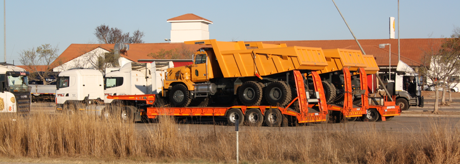
Road Freight
The R101 is an alternate route to the N1 for road freight vehicles. However since the road is a single way, trucks can also contribute to traffic congestion on the road. The towns on the corridor have placed restriction based on the size of the truck on the road. These restrictions ensure that the integrity of the roads is maintained and traffic congestion kept to the minimum.
However, Section 37(4) of the National Land Transport Act, Act No.5 of 2009 states "a person must not transport dangerous substances in the area of a planning authority except on a route so designated and indicated in an integrated transport plan, where such a route has been determined and published".
This Act exists to protect the residents of the district against possible disasters if there is accidental spillage of the substances in the vicinity of residential areas. However these restrictions are not in place in all the towns within the district. This is an area of improvement in terms of signage in all entry points to the towns. The disaster management section of the Waterberg District Municipality should correct this shortcoming as a matter of urgency.
Main Menu

Other Links
Copyright © 2012 Limpopo Province Freight Transport Data Bank | Developed and Powered by Safiri South Africa.